Consultation Digest Issue 67, 18 August 2020: Speed cushion special.

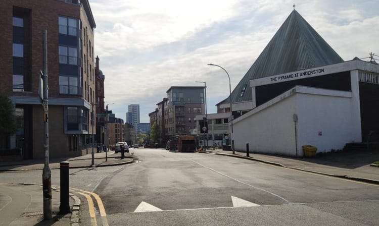
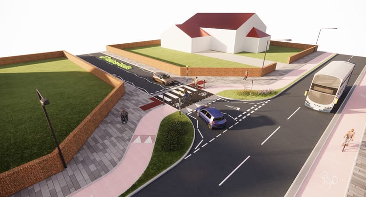
Our feature photo in this Digest shows a road in the east end of Glasgow which is proposed for speed cushion treatment in an attempt to reduce the speed of motor vehicles (see Item 1.4). As private motor cars have increased in width, so has the width of speed cushions and in Section 1 we include 8 speed cushion proposals with speed cushions of 1.8, 1.9 and 2.0m widths, leaving people cycling with the choice of either cycling up and over the speed cushion at a sensible distance from the kerb of 1.0m or in the gap at the kerb, as narrow as 0.5m in many cases, or out in the middle of the road.
Since 18 August last year GoBike has received 20 proposals for traffic calming, primarily on residential streets, in Glasgow using speed cushions, but not one for modal filters to prevent through motor traffic. It is motor traffic that causes deaths and injuries on our roads, with 160 deaths in Scotland recorded in 2018 and many more people injured, yet active travel, particularly in the more deprived areas of the city, fails to get the infrastructure it needs. Speed cushions are tinkering at the edges and a Scotland-wide political solution is required to make our neighbourhoods safe and pleasant for us all.
This isn’t all about speed cushions, though, so do please read on.
Contents
Section 1: Current Consultations
- GoBike Digest Survey, should close today but now extended by 1 week to 25 August
- Glasgow, Merchant City & Trongate Community Council, Merchant City Park petition
- Scottish Government, Town Centre Action Plan Expert Review Group, closes Friday 21 August for written submissions but the survey is open until 30 September
- Glasgow City Council, Gartocher Road (Shettleston) Traffic Calming Scheme, closes 26 August
- Glasgow City Council, Prospecthill Circus (Toryglen) Traffic Calming Scheme, closes 26 August
- Glasgow City Council, Ladyloan Avenue – Extension (Drumry) Traffic Calming Scheme, closes 26 August
- Glasgow City Council, Warriston Street (Carntyne)) Traffic Calming Scheme, closes 26 August
- Glasgow City Council, Greenfield Road (Shettleston) Traffic Calming Scheme, closes 27 August
- **NEW** Glasgow City Council, Renewal of Planning Consent 17/00610/DC, Glasgow Harbour East At Castlebank Quay/Pointhouse Quay/ Yorkhill Quay Glasgow, closes 28 August
- **NEW** Glasgow City Council, Hermiston Road (Shettleston) Traffic Calming Scheme, closes 08 September
- **NEW** Glasgow City Council, Muirhead Road (Baillieston) Traffic Calming Scheme, closes 09 September
- **NEW** Glasgow City Council, Newlands Park Area Traffic Calming Scheme, closes 09 September
- **NEW* South Lanarkshire Council, Hamilton, Abercorn Drive and Chestnut Crescent, Traffic Calming, closes 11 September
- UK Department of Transport, Review of the Highway Code to improve road safety for cyclists, pedestrians and horse riders, closes 27 October 2020
Section 2: Forthcoming Consultations
Section 3: Consultation Feedback
- Multiplex University of Glasgow Campus Development – August 2020 Newsletter
- East Dunbartonshire Local Development Plan No 57, August 2020
- East Renfrewshire, Cycling UK Networking Event 13 August
Section 1: Current Consultations in date order, apart from the first 2, for responses
1.1 GoBike Digest Survey, should close today but now extended by 1 week to 25 August

We do really want to know what you think of these Digests. After over 2 years you must have a view and we have a short, easy-to-do survey for our members.
- For members who participate in our discussions on Slack, please go to the Consultations or General channel and follow the link that is there.
- For members who do not use Slack you may request the link by emailing consultations@gobike.org
- Not yet a GoBike member? You may join from this page and, if you join this week (with a minimum donation of only £5), you will still be eligible to respond to the survey and help us improve the information we are publishing.
1.2 Glasgow, Merchant City & Trongate Community Council, Merchant City Park petition

Many of you will know this wonderful mural on Ingram Street in Glasgow’s Merchant City. GoBike member, Peter, has told us that it is now under threat with a proposal to redevelop the area infront of it, currently used as a car park. A Planning Application to build a hotel has been withdrawn but who knows what might come next?
Merchant City & Trongate Community Council propose that a City Park is constructed on the site and they are looking for your support, with this petition. Please do support this; we need more green space in Glasgow and this is a welcome opportunity to green the city.
1.3 Scottish Government, Town Centre Action Plan Expert Review Group, closes Friday 21 August for written submissions but the survey is open until 30 September

This issue featured as Item 1.4 in Digest 66 and here’s the link to the relevant information. There’s a clear list of questions to respond to and here’s the GoBike response. Note that written responses were requested in word format, if you intend to submit before closing on Friday.
Do please send in your views about our urban centres; they could be so much better than they currently are and the online survey is open for another 6 weeks.
Items 1.4 to 1.8 Traffic Calming
These 5 items were introduced in Digest 66 as Items 1.5 to 1.9 and all the relevant drawings were attached to the items there. Here’s the one letter that GoBike has submitted in response to cover them all. We give brief details of each below but do please write in to the City Council if you disagree with their policy on traffic calming.
1.4 Glasgow City Council, Gartocher Road (Shettleston) Traffic Calming Scheme, closes 26 August

This view is taken looking south though the disused railway bridge that severely limits the width of Gartocher Road. It also completely, under the present space allocation, eliminates any safe space for cycling and any safe space for social distancing on the footway, which is barely wide enough for 2 good friends to walk side by side. According to the GCC drawings the roadway width under this bridge is 5.8m. Since commercial vehicles may be up to 2.55m wide, excluding mirrors, 2 vans passing each other under this bridge don’t leave much room for anything else.
The City Council’s view to resolve concern about speeding vehicles on this road, which runs north from Shettleston Road, is to place 15 speed cushions of varying size and varying spacing along the road, all of them pushing anyone who cycles out of a good position on the road.
It’s GoBike’s view that space here could be better allocated and motor vehicle access should be restricted.
1.5 Glasgow City Council, Prospecthill Circus (Toryglen) Traffic Calming Scheme, closes 26 August

A new development, designed with cars, and not people, in mind. Now action has to be taken to reduce the speed of those cars.
The City Council proposes lots of speed cushions; GoBike suggests safe space for cycling, a staggered series of rain gardens and/or a modal filter halfway round the circus to prevent motor cars from doing a circuit.
1.6 Glasgow City Council, Ladyloan Avenue – Extension (Drumry) Traffic Calming Scheme, closes 26 August

Here we have again, a relatively new development with lots of space for cars, although one driver, at least, has found it “necessary” to park on the footway, thus endangering anyone walking or cycling.
The City Council’s one solution is, of course, speed cushions, but GoBike thinks they should be more imaginative and we suggest that features from the forthcoming Liveable Neighbourhoods Strategy are used and that planters are placed judiciously to determine whether one or more modal filters or simply narrowing of the roadway are sufficient to reduce motor speeds.
1.7 Glasgow City Council, Warriston Street (Carntyne)) Traffic Calming Scheme, closes 26 August

Warriston Street is a residential street, with the 38 bus route running along it. With all the cars stored on the street (or the footway) there isn’t much room for much more than one bus at a time at some locations, yet motor vehicles still exceed the speed limit. Wouldn’t it be much better if the street were re-engineered to limit through traffic to buses and cycles?
1.8 Glasgow City Council, Greenfield Road (Shettleston) Traffic Calming Scheme, closes 27 August

With so many vehicles stored on the road and footway and on quite a gradient, it’s easy to see how residents are concerned about vehicles travelling at speed. However, if through traffic is moved to nearby Springboig Road and a modal filter installed on this road, life could be much pleasanter.
1.9 **NEW** Glasgow City Council, Renewal of Planning Consent 17/00610/DC, Glasgow Harbour East At Castlebank Quay/Pointhouse Quay/ Yorkhill Quay Glasgow, closes 28 August

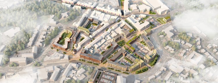
Last week GoBike member, Iain, brought this Renewal of Planning Application to our attention. It’s for the development of the large area around the relatively new Riverside Museum and, not shown on the pretty picture above, is the detail that there will be space for 1300, yes 1300, parked cars! How many bikes? No idea; there’s no mention of active travel or public transport. This is the link to the report on Glasgow Live.
This is a Renewal of Planning Consent 17/00610/DC, for Glasgow Harbour East at Castlebank Quay/Pointhouse Quay/ Yorkhill Quay Glasgow, that is, both sides of the River Kelvin and surrounding the Riverside Museum, south of the Expressway. When the museum was moved to this site there was much talk of public transport links, but this has now reduced, as far as we are aware, to the tourist bus stopping here on its circuit of the city. Thus, for the regular citizen it’s either walking from the bus/train/subway interchange at Partick, cycling, walking or, if you have one, bringing the car.
There is a strong suspicion that this is a done deal, but there are many reasons for concern, most of which have been raised on the GoBike Slack consultation channel:
- No mention of public transport
- No mention of cycling and walking access. National Cycle Route 7 runs through the site and there is no mention or visibility of this. It is difficult on the plan to see the path from the riverside that runs under the Expressway to join up with cycling routes on the north side of the Expressway
- The development is not in line with the Scottish Government’s document Designing Streets nor is it in line with Glasgow City Council’s forthcoming Liveable Neighbourhoods Strategy
- It is not in accordance with the Town Centre Action Plan, see Item 1.3 above
- There is no mention of the impact this development will have on nearby shopping and leisure areas or on the city centre. Any development here should complement the city not be in competition with existing amenities
- There is no justification given for the number 1300 selected for the number of car parking places to be provided, nor any detail of the charges that will be levied on people leaving their cars here.
- It is not in agreement with the findings from City’s Climate Emergency Working Group or current City Council policies on increasing active travel and reducing cars entering the city
- How does a development of this sort tally with the City’s aim of hosting COP26 next year?
- Further housing is planned for South Street, which is already busy with industrial motor traffic; this area around the museum should be developed as a park for people who live in the area, with cycling and walking routes running through it.
- There is no mention of river traffic
- There is no mention of the proposed Govan to Partick pedestrian and cycle bridge, which we are all waiting for and how this will impact on the area
- The Riverside Museum is of notable architectural and engineering interest, and it can be seen from the cycling and walking route, from the Expressway and from the railway. It should not be obliterated from view by buildings of lesser note
From that list it is quite clear that the general view is one of objection and here is the resulting GoBike letter, which lists and amplifies the above points.
Items 1.10 – 1.12, More Traffic Calming in Glasgow
The following 3 items are similar to the 5 Traffic Calming Items above and, to save space, only the full email for the first is shown. As we said in our last Digest we understand that the City Council offers one solution only to Community Councils and Councillors who wish to see the speeds of motor traffic reduced, and that is speed cushions.
1.10 **NEW** Glasgow City Council, Hermiston Road (Shettleston) Traffic Calming Scheme, closes 08 September

Here’s the email that we received on 11 August:
“MESSAGE SENT ON BEHALF OF KEVIN HAMILTON, HEAD OF ROADS, NEIGHBOURHOODS AND SUSTAINABILITY
“Dear Sir / Madam
The Glasgow City Council, (Hermiston Road), Traffic Calming Scheme
The Council propose to consider the introduction of the above named Traffic Calming Scheme and I wish to establish the views of your organisation.
Please note that these proposals will also be released to the public by displaying on-street notices within the affected area.
Background to the proposed Scheme
The scheme is aimed at improving road safety by reducing vehicle speeds.
Roads affected by the proposed Scheme
The road affected by these proposals is:-
>Hermiston Road
Details of the proposed Scheme
The proposed Scheme (as depicted on the attached plan) will comprise of:-
- 9 sets of 3×1.8m wide speed cushions
- The installation of 18 bollards
Please provide any comments you wish to make on these proposals within 28 days.
Please reply directly to LESTraffic@glasgow.gov.uk
In the meantime, should you require any further information or clarification on any points arising from the proposals, please e-mail LESTraffic@glasgow.gov.uk.
Should the Council proceed with these proposals; I will write to you again and confirm this.
Kevin Hamilton
Head of Roads
Neighbourhoods and Sustainability“
The “plan” referred to is these 4 plans:
Section-1-btwn-number-3-and-number-17
Section-2-btwn-number-41-and-number-63
Section-3-btwn-number-67-and-number-97
Section-4-btwn-number-101-and-Tynecastle-Street

Perhaps not too clear on the map above is the fact that Hermiston Road runs parallel to, and 2 streets to the west of, Greenfield Road which, in turn is next to, and parallel to, the main road, Springboig Road. It’s a small residential area with, as the photo above shows, has lots of on road and footway parking and is, particularly at the north end, quite steep. It’s easy to see why speeding motors could cause a hazard.
No-one, though, seems to have asked the question as to whether this needs to be a through road. Could a series of filters ensure that through traffic uses the main roads and does not use roads such as this as rat runs?
1.11 **NEW** Glasgow City Council, Muirhead Road (Baillieston) Traffic Calming Scheme, closes 09 September

Here’s the critical part of the email we received from the City Council on 12 August:
“Details of the proposed Scheme
The proposed Scheme (as depicted on the attached plan) will comprise of:-
- 2 sets of 3×1.9m wide speed cushions
- 6 sets of 2x2m wide speed cushions
- The installation of 16 bollards“
5 plans were attached to the email:
Muirhead-Road-TC-proposals-Full-view
Muirhead-Road-TC-proposals-Section-1
Muirhead-Road-TC-proposals-Section-2
Muirhead-Road-TC-proposals-Section-3
Muirhead-Road-TC-proposals-Section-4

Here we have a road that leads from the main part of Muirhead down to Baillieston Train Station and then on towards Hamilton Road and the M74. Primarily straight, the parked cars will make it tricky for residents to cross the road, particularly if motor vehicles are exceeding the speed limit, but hold on, where are the cycle lanes and even the space for social distancing? The footways, if half-covered by cars, don’t allow for safe distances between people and surely, we should be encouraging people to cycle to the train station, and to cycle generally?
The one solution fits all will do neither, but the speed cushions will push people on bikes either into a gap as narrow as 0.5m at the kerb or well out into the roadway if they wish to avoid the instability and discomfort of cycling over speed cushions.
1.12 **NEW** Glasgow City Council, Newlands Park Area Traffic Calming Scheme, closes 09 September

The four roads proposed for the speed reduction treatment are Beverley Road, Calderwood Road, Carlaverock Road and Lubnaig Road. This looks and feels like an affluent area, with probably a higher proportion of large SUV type cars that can easily cope with speed cushions so why go to the effort and expense of putting them down? Here’s the critical part of the email that arrived from the City Council on 12 August:
“Details of the proposed Scheme
The proposed Scheme (as depicted on the attached plan) will comprise of:-
- 2 sets of 4 (differing width), speed cushions
- 19 sets of 3 (differing width), speed cushions
- The installation of 42 bollards“
10 plans were attached:
Newlands-Park-area-TC-proposals-Beverley-Road-Section-1
Newlands-Park-area-TC-proposals-Beverley-Road-Section-2
Newlands-Park-area-TC-proposals-Calderwood-Road-Section-1
Newlands-Park-area-TC-proposals-Calderwood-Road-Section-2
Newlands-Park-area-TC-proposals-Carlaverock-Road-Section-1
Newlands-Park-area-TC-proposals-Carlaverock-Road-Section-2
Newlands-Park-area-TC-proposals-Carlaverock-Road-Section-3
Newlands-Park-area-TC-proposals-Lubnaig-Road-Section-1
Newlands-Park-area-TC-proposals-Lubnaig-Road-Section-2
Newlands-Park-area-Traffic-Calming-Proposals

This photograph of the junction where Lubnaig Road meets Merrylee Road shows that attempts have been made to reduce motor traffic speed with the guidance 20s plenty signs. Also, you will notice the pavement buildout to ensure that motor traffic enters and leaves Merrylee Road at a tighter angle than previously, which reduces speeds.
The question has to be asked as to why motorists continue to speed in this residential area? If the roads are being used as a rat run from Merrylee Road to Kilmarnock Road than then this can be easily stopped by putting in some modal filters allowing only cycles and emergency vehicles access.

There has been a school in the area, Calderwood Lodge Primary, but it’s now up for sale, probably to be redeveloped into desirable residences for the wealthy. Now is the time to reduce through traffic and encourage people to walk and cycle into and around the very pleasant Newlands Park.
1.13 South Lanarkshire Council, Hamilton, Abercorn Drive and Chestnut Crescent, Traffic Calming, closes 11 September

In Digest 46, Item 1.3, issued in October last year, were details of a filter proposed by South Lanarkshire Council to remove through motor traffic from Chestnut Crescent to Silvertonhill Avenue in Hamilton. Unfortunately 80% of respondents to the Council’s survey rejected this idea and the Council now propose traffic calming with, yes, you’ve guessed, speed cushions on both Abercorn Drive and Chestnut Crescent in an attempt to reduce motor speeds.

Here’s a Google view of Abercorn Drive near its junction with Chestnut Crescent and it already looks as if it would be difficult to drive at any significant speed. There look to already be speed tables and 20mph roundels on the road, plus illegal parking.
Here are the details of the proposals and here is a plan of the traffic management proposals. We will be looking at these over the next week or so and hope to have a response in the next Digest. However, if you know the area and have views on the proposals do please respond to the survey and email consultations@gobike.org to help our response.
1.14 UK Department of Transport, Review of the Highway Code to improve road safety for cyclists, pedestrians and horse riders, closes 27 October 2020

This UK-wide consultation first appeared as Item 1.10 in Digest 66 published 2 weeks ago.
We continue to develop our response to this consultation and we are receiving views from several quarters. Unfortunately not many of these are hopeful that the proposed changes will bring about significant improvements for those of us who are vulnerable to injury from large vehicles and the predominance of motor vehicles on our roads. Many of the proposals are for guidance only, ie using the word “should” rather than the mandatory “must”. We will, though, continue to draft a responsible input to the discussion and we will keep you informed of progress.
Section 2: Forthcoming Consultations
Nothing that we are aware of just now.
Section 3: Consultation Feedback
3.1 Multiplex University of Glasgow Campus Development – August 2020 Newsletter

Here’s the latest edition of the Multiplex University of Glasgow Newsletter August 2020, which we received on 10 August.
3.2 East Dunbartonshire Local Development Plan No 57, August 2020
This newsletter arrived today from East Dunbartonshire Council’s Land Planning Policy team. There’s no specific mention of cycling but those of you you know East Dunbartonshire well might see more in the detail.
3.3 East Renfrewshire, Cycling UK Networking Event 13 August
This event was advertised in Digest 66, Item 2.1 and GoBike co-Convenor, Thomas, took part in the virtual event. Here’s his brief report, a good note on which to end this Digest:
“The East Ren Networking meeting aimed at cycling was well attended and we give thanks to Cycling U.K. Scotland’s Eileen Hamill for arranging it all. It wasn’t groundbreaking but it’s a good first step to helping improve access and forward motion to creating a better East Renfrewshire.“
**********************************************************
