Consultation Digest (Local) Issue 79, 2 February 2021

Quick trips to the seaside, countryside and updates from around the city.
In this Digest there are two projects by housing associations to improve active travel connections. The South Lanarkshire, (Y)our Districts and Woodside consultations are each from a wider ongoing series of events but could play a big part in shaping the areas they cover. Lastly there’s a follow-up about East Renfrewshire and a few newsletters.
If you’re in the city, see Andy’s three infrastructure routes around Glasgow to take in new Spaces for People infrastructure. He’s also started to inform GoBike about closures and diversions; if you hear of any please do let us know.
This Digest includes links in the Contents page so you can jump straight to a topic if you want to.
Contents
(new consultations in bold)
Section 1: Current Consultations
- North Ayrshire Council – Ardrossan Connections Project, closes 3 February
- South Lanarkshire Council – Active travel online consultations, all close 8 February
- Glasgow City Council – (Y)our Districts Online Ideas Workshops – ‘Learning Quarter’, rescheduled online sessions Thursday 18th February
- Queens Cross Housing Association – Woodside Making Places: updated masterplan and online public meeting – 25 February
Section 2: Forthcoming Consultations
None
Section 3: Consultation Feedback
- Fenwick Rd, East Refrewshire – online meeting follow-up
- New Gorbals Housing Association – Planning application 20/03363/FUL
- Sustrans – Glasgow Cycle Counters
- Urban Roots – Malls Mire newsletter
- Multiplex – Glasgow University campus newsletters
- North Lanarkshire Council – Local Development Plan Progress Update
Section 1: Current Consultations
(in date order for responses)
1.1: North Ayrshire Council – Ardrossan Connections Project (closes 3 February)
As covered in Digest 78, Sustrans are running a Commonplace consultation about Ardrossan town centre for North Ayrshire Council and Ardrossan Community Development Trust. This project seems to focus on the on-road bit between NCN73 and NCN753. If you know the area, see the Ardrossan Connections Commonplace map. You’ll need to be quick as it closes tomorrow, 3 February.
1.2: South Lanarkshire Council – Active travel online consultations (all close 8 February)
Not one but three consultations, as covered in Digest 78. They’re for Blantyre/Bothwell/Uddingston; Larkhall and Strathaven/Stonehouse (and surrounding villages). NCN74 passes through these towns (except Strathaven) on a mixture of roads and shared paths. None have segregated cycleways for bikes only. What routes could be upgraded and added on to form a network? This is a great chance to ask for improvements.
Strathaven has a former rail line going east-west behind Sainsbury’s which could make a great cycle path. Most routes in Stonehouse are on road, including NCN74. The A71 cuts off part of its former rail line but it does have others towards Strathaven, Larkhall and Blackwood. In Larkhall, NCN74 moves onto shared paths from the back of the town centre towards Ferniegair and Chatelherault Country Park.

Blantyre currently has a section of NCN74 alongside the East Kilbride Expressway and Glasgow Rd. The latter could easily be widened before the section through Stonefield Park. It then links Station Rd, Blantyre via the David Livingstone Bridge over the River Clyde to Station Rd, Bothwell. The ‘Nature Trail’ here shows what can be done with a former rail line. A new section of NCN74 is due to link from the Raith Interchange to Laighlands Rd, Bothwell. This section currently features a hay bale acting as a filter to stop drivers using the shared path as a rat run!

NCN74 continues into Uddingston on Wilkie Rd, where a new toucan crossing on Bellshill Rd has improved the route. It also links to NCN75, which goes past the train station and Uddingston Grammar School. SLC have already drawn up a network plan for Cambuslang and Newton after a similar consultation. That raised the prospect of finally re-routing NCN75 to avoid the climb up Westburn Rd – a missing link in the Clyde Walkway route that would benefit many, including local school children. Equally, a segregated route along Glasgow Rd from Uddingston towards Glasgow would be very popular.
See SLC’s active travel consultations page for links to each survey/map. You’ve got less than a week to respond – deadline for all three is 8 February.
1.3: Glasgow City Council – (Y)our Districts Online Ideas Workshops – ‘Learning Quarter’

GCC’s ongoing Districts consultations were recently mentioned in Digest 78. The planned ‘Learning Quarter’ workshops were postponed with a new date to follow.
The new workshops have been announced for Thursday 18th February. There’s an afternoon session (2–4pm) and an evening session (6–8pm) both using Zoom. You can still comment on the Districts Commonplace map.
Other relevant consultations about the wider area appeared in Digest 74, including Strathclyde Uni’s proposed active travel project and the North Glasgow Strategic Development Plan.
1.4: Queens Cross Housing Association – Woodside Making Places: updated masterplan and online public meeting – 25 February
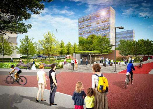
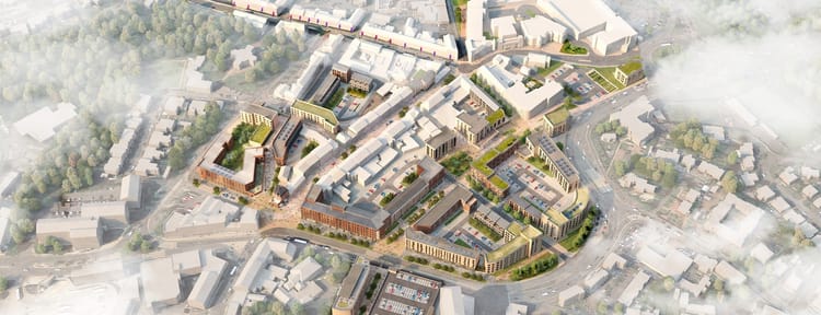
The Woodside Making Places project last appeared in Digest 65. It covers an area around St George’s Rd, between Maryhill Rd and Garscube Rd. These are mainly residential streets with large blocks of low, mid and high rise flats (plus a few tenements). As well as the new segregated cycleway on St George’s Rd, crossings will be added on N Woodside Rd and other measures include gardens and outdoor play areas (there are three schools nearby).
GoBike received an email from the Making Places team:
“Plans to transform the landscape of Woodside have been advancing since the last phase of community consultation in Summer 2020, and you can now see on the updated Woodside Making Places website how the masterplan has evolved in response to your comments, as well as consultations with stakeholders and statutory bodies.
Please explore the updated masterplan design – which you can now zoom-in to and post additional comments directly onto. Your ongoing comments are valued, and will help us to further refine the design; you can see how we have responded to those submitted during the previous stage.”
The masterplan design is on an interactive map site called Placechangers (similar to Commonplace/Placecheck). Early comments seem to be from residents about anti-social behaviour and other concerns with the current environment, rather than the future plans. It should make for an interesting online public meeting on Thursday 25th February.
Section 2: Forthcoming Consultations
None this time.
Section 3: Consultation Feedback
3.1: Fenwick Rd, East Refrewshire – online meeting follow-up
Digest 78 covered the Fenwick Rd situation in Giffnock . This meeting took place on 18 January, right before its issue, and some local GoBike members took part. The meeting’s chair was Eastwood MSP Jackson Carlaw, whose background as a car salesman didn’t inspire confidence. However, it did represent active travel issues as mentioned in his email response:
“A number of reasonable concerns were expressed, not about the principle of the temporary secure route but more specifically about its width and appearance and how it might subsequently be extended beyond Church Road. I am grateful for the constructive comments and suggestions from active cyclists in the immediate area who have been able to engage with neighbours and others locally. Having previously lived immediately adjacent to this scheme for some twelve years with young children, I do appreciate the various views.”
He mentions meeting Lorraine Macmillan, East Renfrewshire Council’s Chief Executive:
“I did feed in the positive support for safer streets initiatives, preferably segregated where possible, but noted the views expressed that when the temporary arrangements at Fenwick Road end and when a more permanent scheme might be considered, that this learn from the experience gained and views of those locally. I also noted the need to ensure that any proposal to extend the scheme should not prejudice local trading but ensure that this is secured together with the interests of all users.
I also took the opportunity to note the considerably increased wider cycling and pedestrian use of local streets over the last year which we have all witnessed. Some key routes which attract many are frankly not currently as safe or suitable as they might be at present. Making them so should be an objective for the immediate future. Many years ago (I am reaching back to the late 1960s here!) I can recall sections of Mearns Road being equally unsuitable and a solution achieved then was for a strip of land on the other side of the previous pavement/hedge boundary to be secured for pedestrians and cyclists. This may be a way forward and worth exploring on certain popular routes now.”
While we might not be asking Mr Carlaw for design tips, at least it’s a fairly pragmatic response and not the one-sided view it might have been. It remains to be seen how the rest of the Spaces for People trial progresses and what happens when it’s removed. You can still have your say on that – see ERC Spaces for People surveys.
3.2: New Gorbals Housing Association – Planning application 20/03363/FUL
This came in from Tricia via a former colleague who writes: “New Gorbals Housing Association has submitted designs to create a pedestrian link by opening up a railway arch between Laurieston Road and Cleland Lane. It’s part of a phased project aimed at improving pedestrian connections and public realm in the area, including turning adjacent greenspace into a park and reducing the width of four-lane Laurieston Road. Acting alongside Network Rail, which has planning permission to introduce commercial uses to a set of arches at Cleland Lane, the latest proposal will establish an east-west link to Gorbals Street, augmented at a later date with new paving and street crossings.”

The arch is just past the Five Ways junction (Brazen Head) on the South City Way. While the link isn’t strictly a cycle route there could be benefits for cycling between Laurieston and the Gorbals. There seems to have been a short consultation period, which unfortunately closed for comments on Tuesday 26 January. See the archway plans on GCC’s Planning portal, where you should be able to follow its progress.
3.3: Sustrans – Glasgow Cycle Counters
GoBike member Peter has been in touch with Sustrans about cycle counters over the past few months. Glasgow has had two public counters (with the digital numbers, etc.) for a number of years. The one at Glasgow Green (near Saltmarket) has been setting record-breaking figures throughout 2020. The other, at the spiral on the West City Way, hasn’t been counting anything for the past few years since it stopped working. The expectation was a new counter would appear elsewhere to replace it.
That is happening but we’re getting two new counters – one for the WCW counter and another to replace the current Glasgow Green counter. According to a reply from Sustrans:
“Further to your email below I can confirm that the two replacement cycle counters were installed in the following locations:
- NCN75 at St. Andrew’s Suspension Bridge
- NCN75 at Cuningar Loop Footbridge.”
Assuming the first location is on the north bank, that is a very busy path. However, not everyone would use it depending on where they were going in the East End. Whereas most of Glasgow cycled on the path near Saltmarket at one time or another last year.
The second location needs a bit of explaining. Cuningar Park (not officially a ‘Loop’ anymore) is on the Rutherglen, South Lanarkshire side of the Clyde. After the Commonwealth Games the footbridge linked it to the former Athletes Village in Dalmarnock. While more people discovered the park during lockdown in 2020 it’s still a bit obscure. A lot more people might use it if the bridge actually linked directly to NCN75 below it, but it doesn’t (although there is a way to get there round the houses, literally). If the counter is actually on the NCN/Clyde Walkway itself, near the bridge, then it makes a bit more sense.
If any of you have seen these in the wild, feel free to tweet/send in photos of how the figures are doing. Meanwhile, we wish the Glasgow Green/Saltmarket counter a well earned rest and a happy retirement!
3.4: Urban Roots – Malls Mire newsletter
We featured the first issue of the Malls Mire newsletter in Digest 74. The January 2021 issue has a rough timetable for the project with milestones to look forward to in spring and summer. The rest is about NatureScot (formerly Scottish Natural Heritage) and Urban Roots themselves. The area looks like it could shape up to be a nice link between Toryglen and Rutherglen.
3.5: Multiplex – Glasgow University campus newsletters
Your editor forgot to include Multiplex’s January newsletter (mainly about traffic management). So, it’s a double helping of Glasgow Uni campus news (four whole pages!). However, their February issue contains drainage works (from January) and a building named ARC (about 20 years after the Glasgow Caley ARC building). Where would we be without these West End avant garde types, eh?
3.6: North Lanarkshire Council – Local Development Plan Progress Update
GoBike received a brief update from North Lanarkshire Council:
“Our Local Development Plan – Modified Proposed Plan is currently progressing through the Planning and Environmental Appeals Division (DPEA) examination process.
The DPEA have made a number of requests for further information. We are working to provide all information requested, meantime you can follow progress online.”
Just in case you were wondering how the plan was doing; now you know.

