Consultation Digest (Local) Issue 93, 17 August 2021

Consultations from around Glasgow.
This Digest covers most points of the compass in Glasgow and neighbouring areas to the west, south and east.
Quite a few local and national petitions have been launched recently so this Digest has an update on those (instead of infrastructure).
Petitions Update
- GoBike – Keep our paths open for COP26 (Glasgow residents only)
- Cycling UK – Help fix our failing road traffic laws
- Living Streets – petition to bring forward the ban on pavement parking (and there's a launch event for a new Glasgow branch of Living Streets)
- Progress for GoBike member Patricia's petition on public toilets
- A potential future petition about making cycling infrastructure fit for purpose by the broadcaster/author Ned Boulting
Contents
(new consultations in bold – link jumps to article)
Section 1: Current Consultations
- Glasgow City Council – Auldhouse Area Traffic Management Order (ends 20 Aug)
- North Lanarkshire Council – Bellshill Entrance/Velo Park Project (until end of Aug)
- East Renfrewshire Council – Ayr Road (A77): Spaces for People, Phase 2
- Glasgow City Council – Low Emission Zone consultation (ends 2 Sep)
- Rosemount Development Trust – Royston Road Masterplan (ends 3 Sep)
- Glasgow City Council – Inner East Strategic Development Framework (ends 3 Sep)
- Renfrewshire Council – Improving Barshaw Park Junction, Paisley (ends 5 Sep)
- East Dunbartonshire Council – Active Travel Discussion (ends 28 Sep)
Section 2: Forthcoming Consultations
None this time.
Section 3: Consultation Feedback
- Glasgow City Council – Active Travel Forum Network map
- Urban Roots – Malls Mire partial opening (and newsletter July 2021)
- Glasgow City Council – Maryhill Road/North Woodside Road/Hopehill Road
- Glasgow City Council – TRNSMT Festival and Access to NCN75
- Multiplex – Glasgow Uni campus contact changes (and newsletter August 2021)
- Glasgow City Council – Garnethill Traffic Management and Parking Controls Order
Section 1: Current Consultations
(in date order for responses)
1.1: Glasgow City Council – Auldhouse Area Traffic Management Order
The Auldhouse area order appeared in the last Digest 92, Item 1.8. It applies to a triangle of land in the Southside, just off Kilmarnock Rd and Nether Auldhouse Rd. The TRO deals with parking restrictions and making some lanes access only for motor vehicles. See our GoBike response to the Auldhouse Area order. See the Auldhouse plan PDF or the above link for the rest of the documents (ends 20 Aug).
1.2: North Lanarkshire Council – Bellshill Entrance/Velo Park Project
As seen in the last Digest 92, Item 1.9, the new velo park would be at the edge of Bellshill (next to Motherwell Rd/A721) with mountain bike trails down into Strathclyde Country Park. The project lead is due to meet local community groups in the next week or so. A GoBike member should be at one of the meetings so we'll hopefully have feedback next time.
If you cycle in the park or the wider area, see the Bellshill Entrance & Velo Park info page. The page says the process should lead to a Sport Scotland application this month so email the council before the end of August.
1.3: East Renfrewshire Council – Ayr Road (A77): Spaces for People, Phase 2
As covered in Digest 91, Item 1.5, Ayr Rd through Newton Mearns has a phase 2 consultation. It's about replacing the phase 1 cones with light segregation, removing some segregation and adding parking bays. For examples of the segregation, maps and more details, see the Ayr Road Phase 2 Commonplace page. No obvious deadline on this one.
1.4: Glasgow City Council – Low Emission Zone consultation
As in Digest 90, Item 1.3 this consultation is about phase 2 of the Low Emission Zone in Glasgow city centre (between the M8, river and High St). Phase 1 applied to local buses but phase 2 will include all vehicles entering the zone area (unless exempt). However, enforcement is only due to start in June 2023.
The short survey asks you about issues like the LEZ area and the grace periods. See the Glasgow LEZ consultation page and LEZ online survey. Closes on 2 September 2021.
1.5: Rosemount Development Trust – Royston Road Masterplan
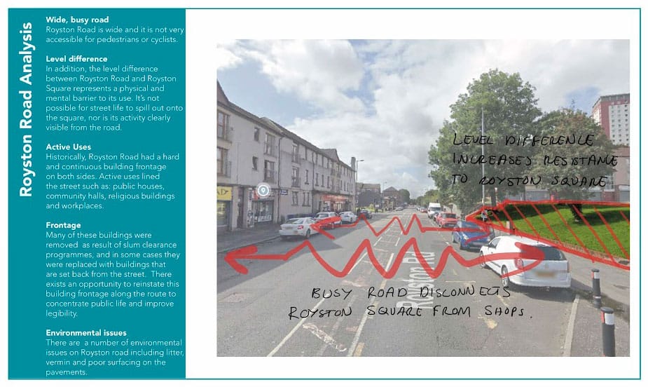
Projects about Royston Rd seem to be like buses – none for ages then two at once. The last Digest 92, Item 1.2, featured the Flourishing Molendinar project about the area at the eastern (hilly) end of Royston Rd. The western (flat) end of Royston Rd is the focus of this project by Rosemount Development Trust.
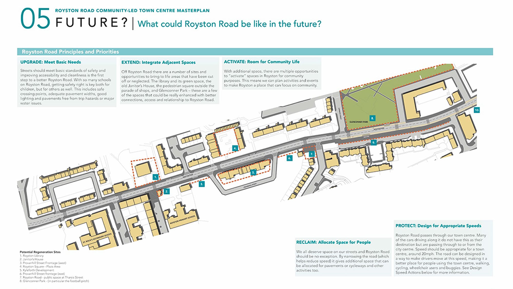
This section is a crucial link from the city centre/Sighthill (to the west) up towards Blackhill (to the east). Current plans only mention cycling in passing, which is a concern. If cycleways don't connect right along Royston Rd it risks cutting off not only Blackhill but also active travel routes from places in North Lanarkshire like Stepps and Cumbernauld.
If you know the area at all, please put a word in for cycling. See the Royston regeneration survey and information boards (ends 3 Sep).
1.6: Glasgow City Council – Inner East Strategic Development Framework
East of High St out to Carntyne and Tollcross is the ‘Inner East’ area, covered in the latest SDF (as in Digest 90, Item 1.4). The ‘Connected’ section 4C mentions cycling infrastructure projects but also public transport and roads, including the so-called East End Regeneration Route (EERR) dual carriageway.
See the Inner East consultation page for link to the SDF survey (ends 3 Sep).
1.7: Renfrewshire Council – Improving Barshaw Park Junction, Paisley
In 2017, Sustrans identified this crossroads as a dangerous junction. It's at the entrance to Barshaw Park in Paisley where Arkleston Rd and Hawkhead Rd meet Glasgow Rd (A761, which becomes Paisley Rd West in Glasgow). Arkleston Rd runs south from the M8 and is used for car parking next to Barshaw Park. The park itself includes a BMX track and a mini street layout for children learning to cycle.
This month, Renfrewshire Council announced they had won Places for Everyone funding for the junction.
The consultation has three options:
- Glasgow Rd protected lanes (none on Arkleston Rd or Hawkhead Rd) plus 'early start' cycle traffic lights (Option 1 PDF)
- All roads have protected lanes with 'early start' cycle traffic lights (Option 2 PDF)
- A protected junction with protected lanes on all roads and bikes get their own signal phase (Option 3 PDF)
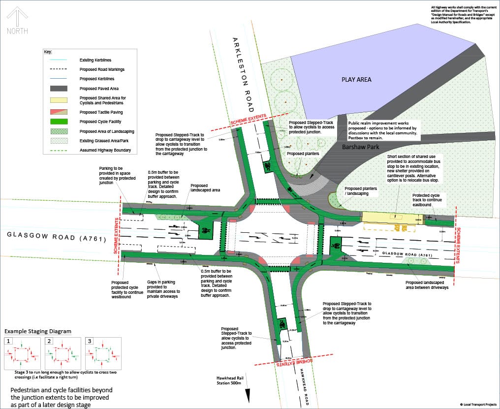
Experience from Edinburgh with 'early start' bike traffic lights is that not everyone wants/can get to the front of a traffic queue to make use of them. The last option seems best but it creates a bus stop in-shot with shared path alongside it (where Glasgow Rd would be narrowed from two lanes to one). The plans mention relocating the bus stop as another option (but it is next to the main park entrance). Any further protected cycle lanes on roads would be added in a later phase.
Nearly every comment about the plans on Facebook seems to be hostile to all three options (on posts by Renfrewshire Live, The Mill magazine or Friends of Barshaw Park). The most common point (apart from rants about cycling) was the lack of a right-turn filter/light from Arkleston Rd onto Glasgow Rd. If you know the area at all, see the Barshaw Park junction community survey to rate the options (ends 5 September).
1.8: East Dunbartonshire Council – Active Travel Discussion
This has featured since Digest 86, Item 1.2, with its ‘Ideas Map‘ for the area. It’s an opportunity to focus on active travel (walking, cycling and wheeling).
Online discussion events restart from 21 August (Bearsden & Milngavie). See a full list of events and background info on the Active Travel Discussion webpage. Closing date – 28 Sep 2021.
Section 2: Forthcoming Consultations
None this time.
Section 3: Consultation Feedback
3.1: Glasgow City Council – Active Travel Forum network map
We last heard from GCC's Active Travel Forum when it restarted in March (the ATF has stopped and started a few times in its history). The most recent meeting, in June, included a new proposal for a city network, which has now been published online. We've seen vague outlines before, like the City Ways map in the last Cycling Strategy. The new map isn't that easy to follow (compared to similar network maps for South Lanarkshire Council). However, this new Glasgow network map does seem to be more systematic than any previous ones.
The presentation about the network map talks about the method behind producing it, including an algorithm for key destinations and roads >10m wide. Slides also mention soft segregation and filters as part of the network. So, it wouldn't necessarily all be segregated but might go in quicker. The recent announcement about the Liveable Neighbourhoods project (and its Toolkit) may play a part in that.
Slide 10 talks about the density of the network, sets a timescale and another disclaimer:
"CITY Network Map
- Proposed city network to be in place by 2030
- Represents the required density of routes for a functional City Network
- Not all of these streets identified here will form the City Network as delivered but form the start of the planning and prioritisation process
- Delivered City Network must be of equivalent density and coherence by 2030 to enable easy everyday active journeys "
So, the current routes on the map may not be the final ones (and there's no key).
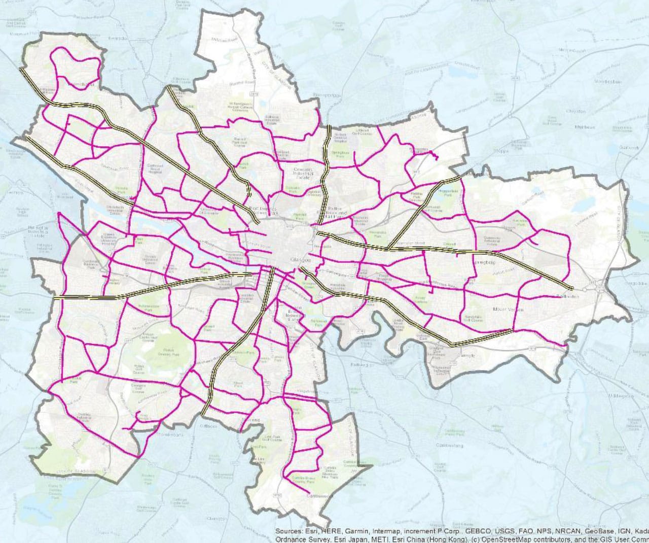
Main route corridors (striped lines, clockwise from north):
- Springburn Road (A803)
- Alexandra Parade/Cumbernauld Road/Edinburgh Road (A8)
- Cumbernauld Road (A80)
- London Road (A74)
- Eglinton Street/Pollokshaws Road/Kilmarnock Road (A77)
- Paisley Road West (A761)
- Victoria Park Drive South/Dumbarton Road (A814)
- Great Western Road (A82)
- Maryhill Road (A81)
All of the above are (at least) four lane A-roads but it's not clear if these are intended as the main cycle routes. However, London Rd already has a section of permanent cycleway at either end with more phases planned. London Rd also has sections of soft segregation (with large gaps), as do parts of Cumbernauld Rd and Gt Western Rd. The empty area in the city centre would presumably connect to Avenues project routes. Most of the striped routes reach the city boundary, apart from London Rd and Edinburgh Rd.
The pink routes on the map include permanent infrastructure like the recently completed Garscube Rd cycleway and the very much ongoing South City Way.
The following slide shows 'iterations' and distance/coverage (and has a key!).
Iteration/Distance map
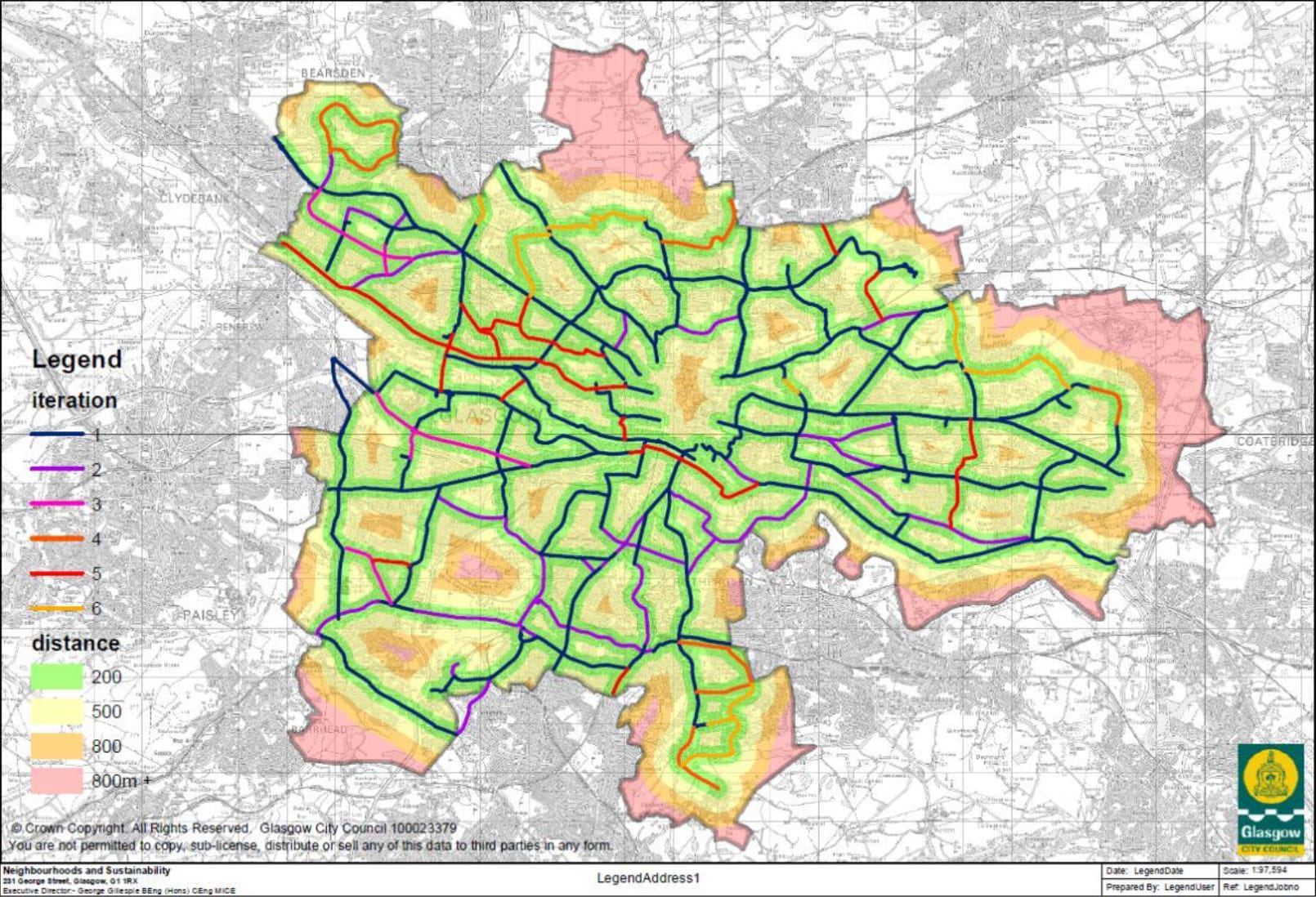
The map seems to show a fairly widespread first iteration/version of the network. It would be followed by additions to fill in gaps between these routes for later versions. The colours show pretty good coverage for most areas of the city compared to now (from 'iteration 6', presumably in 2030). Most of the pink areas (>800m distance) are not residential – they include the Seven Lochs and Pollok Park.
All of this has to be taken with a big pinch of salt (especially the bits outside the GCC boundary at Renfrew and Thornliebank!). It also remains to be seen how it fits in with other council plans and priorities. For example, cycle routes seem to avoid the High St, despite the fact it's not an Avenue but has its own High St Area Strategy project (as well as being part of the 'Learning Quarter' district plan and Inner East SDF). Elsewhere, there are bus priority lanes in the works for Paisley Rd West – will they trump cycle lanes?
The presentation also mentions themes and objectives for the forthcoming Active Travel Strategy (slide 17 onwards). Slide 21 has more detail on 'Proposed Theme 1: Infrastructure & Networks'. Only time will tell how both the strategy and network map are put into practice. However, the map seems like a step towards a more comprehensive network. The proposals should go to committee later in the year.
3.2: Urban Roots – Malls Mire
Malls Mire gets a bit higher up the running order this time as the west and central areas of the new community woodland are due to open in mid-August. These will add much needed greenspace and a network of traffic-free paths in the Toryglen/Polmadie area. When the eastern end of the woodland opens, it will provide extra east-west links between the Southside of Glasgow and Rutherglen, South Lanarkshire.
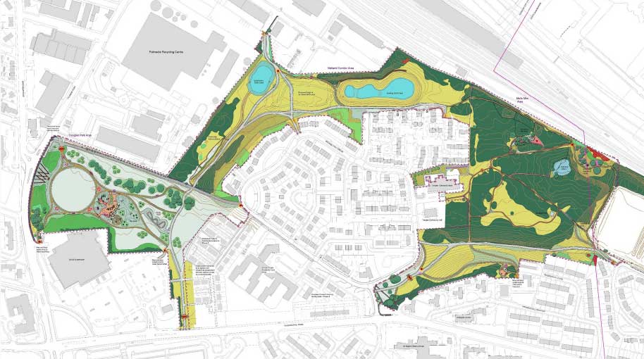
Woodland paths aren't a complete solution to the connection issues in the city network map but they're certainly welcome. In future, Malls Mire may link to enhanced routes in South Lanarkshire Council's Cambuslang/Rutherglen active travel network, like NCN756 towards Shawfield and Glasgow Green.
See the Malls Mire July 2021 newsletter for more information about the latest developments. Well done to Gemma and the rest of the team for all the progress so far.
3.3: Glasgow City Council – Maryhill Road/North Woodside Road/Hopehill Road
First covered in Digest 86, Item 1.1, this novel junction layout caused a bit of head scratching due to its minimalist drawing. Options for the crossing had already been in a consultation for Connecting Woodside. However, there was another more detailed drawing for the new junction layout (PDF).
GoBike sent a letter of objection and received the following reply:
"In response to your comments regarding the desire line to travel north from Hopehill Road to Maryhill Road. I would advise that the design for the above junction does not prohibit cyclists wishing to travel, on the carriageway, from Hopehill Road northbound onto Maryhill Road. Cyclists wishing to travel on the carriageway are both encouraged and supported through the inclusion of Advanced Stop Lines (ASL) at all arms of the junction, to support their journey along either Maryhill Road or Hopehill Road.
Please note, whilst it is the objective of the proposed to improve the conditions for cycling on North Woodside Road and, encourage the uptake of cycling in the local area by introducing additional infrastructure that is suitable for use by all ages and abilities. It is not our objective to dissuade or restrict confident cyclists from using Maryhill Road to continue their journey and as such, we have incorporated dropped kerbs within the design of the junction to make this possible.
As you have stated, should cyclists ‘routinely ignore’ the TRO restricting their movements whilst on the proposed cycle crossing, this would be a matter for Police Scotland. As we advised previously, once approved, a TRO is a legal order and is enforceable by law. If you do however have concerns regarding the speed of vehicles travelling on Maryhill Road, or any of the surrounding roads, I would be happy to bring this to the attention of our Road Safety Team to investigate further."
It remains to be seen how intuitive, or not, this new junction turns out to be. Also, whether Police Scotland take any more interest in anyone ignoring the rules than they do with cars parked in bike lanes. Further phases of Connecting Woodside or results of the city network plan may have a bearing on the junction in future.
3.4: Glasgow City Council – TRNSMT Festival and Access to NCN75
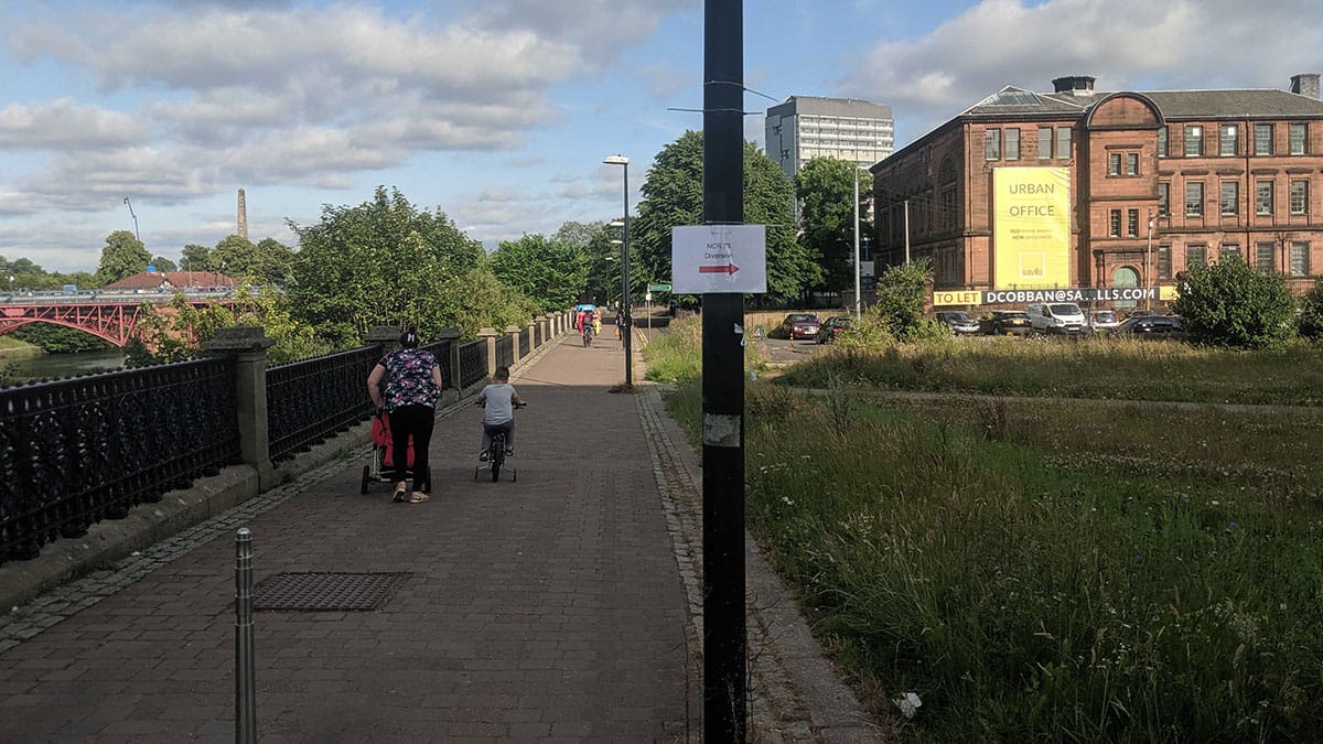
The busy NCN path in Glasgow Green was recently kept open during the Euro 2020 Fanzone in the park. GoBike member Bob wrote to GCC about keeping access to the path in Glasgow Green while it holds the TRNSMT music festival (pronounced 'Transmit', kids). The last edition of the festival, in 2019, had closed the route with very poor signage of the diversion. This led to a previous petition about keeping NCN75 open.
The council's (edited) reply:
"…closure and diversion of the NCR 75 will only take place on the ‘Live Concert’ dates of this event. That will be Thursday 9 September – Sunday 12 September (4 days in total) and that all other dates during the build and break for the event, the NCR 75 will in the main be remain open.
…I would also like to advise that more permanent signage is in place around the diversion routes which when required can be opened to ensure users have a clearly marked route to follow in both directions. These signs will be supplemented with additional free standing signage at some locations. I believe those measures are fair and reasonable for the short term diversion of the route which are in line with other diversionary arrangements.
Lastly I note your objections to any closures but I should can advise that those proposed are governed under the delegated powers granted to the City and managed by Neighbourhoods, Regeneration and Sustainability and are not by their duration subject to consultation."
TRNSMT takes place from Friday 10 – Sunday 12 September 2021 but it sounds like NCN75 will close on Thursday 9 Sep, while they set up.
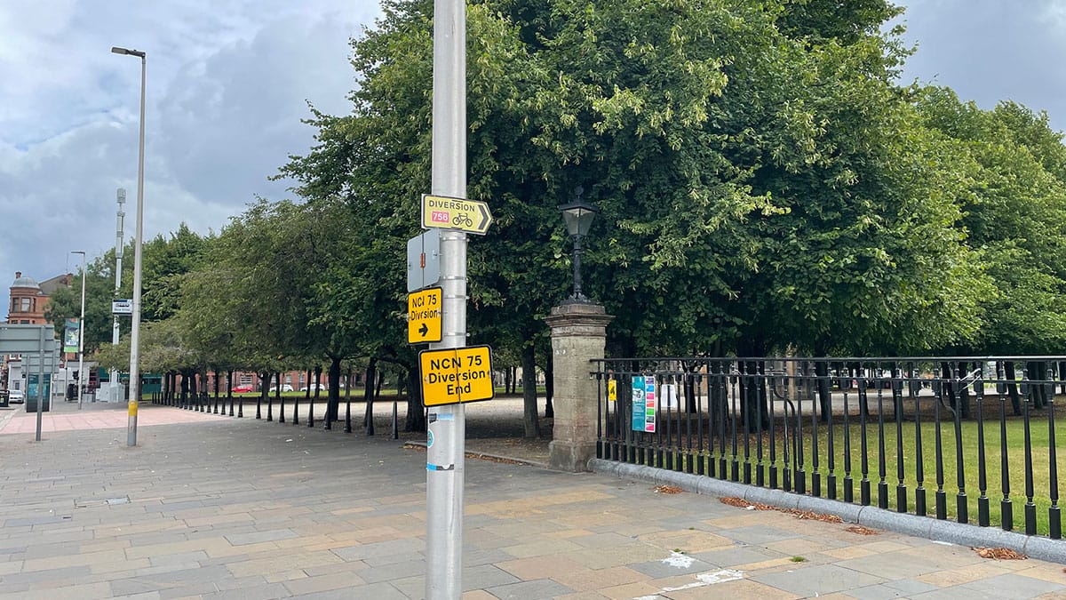
GoBike convenor Thomas posted a thread on Twitter with photos of the diversion route along Adelphi St to the St Andrews suspension bridge. It includes the Gorbals section of riverbank which collapsed in 2017 and remains fenced off. While passable, it's not geared up for the level of pedestrian and cycle use NCN75 gets on an average weekend.
We'll try to find out why NCN75 was open for the Fanzone but closed for TRNSMT.
3.5: Multiplex – Glasgow Uni campus newsletter
The latest update from the Glasgow Uni campus August 2021 newsletter. It sounds like people in the West End are due to see more activity during August as the foundations of the new Business School are laid.
The contact for the project has changed to Fergus Shaw. Best wishes to the previous contact Kieran Ronnie, who helped us with an issue with the temporary traffic lights on University Ave.
3.6: Glasgow City Council – Garnethill Traffic Management and Parking Controls Order
In Digest 91, Item 1.3, we covered the parking controls for Garnethill. GoBike member Tim sent an objection to the plans. He had a response from the council on some of the points raised:
"I can advise that to accommodate the number of resident permits that are purchased for the Garnethill area we could not reduce the number of parking bays in the Garnethill area.
Please note that the reduction in permit price is being proposed to bring the Garnethill zone in line with all other restricted/controlled parking zones out with the City Centre(excluding Hillhead)."
Garnethill is one block from Sauchiehall St so most people would probably think of it as part of the city centre. It is close to main bus routes, train and underground stations but didn't get any Bikehangar secure cycle parking. It's also close to a large motorway junction at Charing Cross, which may have a bearing on the number of cars in the area.
The response also repeated previous statements about Police Scotland ruling out contraflow cycling on one-way streets.

