Consultation Digest (Local) Issue 94, 31 August 2021

Consultations baton change.
As the 2020 Paralympics take place in Tokyo, how is Glasgow looking towards its own global event: COP26? Currently, the city council has a new, short notice consultation about suspending public access rights. You may have seen GoBike banners on the subject or media coverage of support from Scotland’s new Active Travel minister – Green MSP, Patrick Harvie. It’s also a last call for the survey on Glasgow’s Low Emission Zone.
It’s a final fling for a handful of consultations around Glasgow (and one in Renfrewshire). There’s a bit longer for a few others – a new survey on secure cycle parking in the city centre and the last leg of East Dunbartonshire’s Active Travel Discussion.
Your author is also going on holiday so the next Digest may or may not be in its usual slot or by its usual writer…
Contents
(new consultations in bold – link jumps to article)
Section 1: Current Consultations
- Glasgow City Council – Low Emission Zone consultation (ends 2 Sep)
- Glasgow City Council – COP 26 Section 11 Order: Suspension of Public Access Rights (ends 3 Sep)
- Rosemount Development Trust – Royston Road Masterplan (ends 3 Sep)
- Glasgow City Council – Inner East Strategic Development Framework (ends 3 Sep)
- Renfrewshire Council – Improving Barshaw Park Junction, Paisley (ends 5 Sep)
- Queens Cross Housing Association – Woodside Making Places: Planning Application (deadline: 6 Sep)
- NHS Greater Glasgow & Clyde/Sustrans – Gartnavel Active Travel Feasibility Study (ends 10 Sep)
- East Renfrewshire Council – Ayr Road (A77): Spaces for People, Phase 2
- East Dunbartonshire Council – Active Travel Discussion (ends 28 Sep)
- Glasgow City Council – Secure City Cycle Parking Survey (ends 3 Oct)
Section 2: Forthcoming Consultations
None this time.
Section 3: Consultation Feedback
- Glasgow City Council – TRNSMT Festival and Access to NCN75
- North Lanarkshire Council – Bellshill Gateway & Cycle Facilities project
- Glasgow City Council – London Rd Spaces for People lanes at Celtic Park
- East Renfrewshire Council – Proposed Local Development Plan 2
- Glasgow City Council – Auldhouse Area Traffic Management Order
Section 1: Current Consultations
(in date order for responses)
1.1: Glasgow City Council – Low Emission Zone consultation
It was Digest 90, Item 1.3 when we first mentioned this consultation about phase 2 of the Low Emission Zone in Glasgow city centre. Phase 1 applied to local buses only. Phase 2 will include all motor vehicles driven into the zone area between the M8, river and High St (unless exempt, like Blue Badge holders).
The LEZ area is smaller than the City Centre Air Quality Management area, which includes the M8 and parts of Bridge St and Royston Rd. There are only two other AQMAs in Glasgow – Byres Rd/Dumbarton Rd and Parkhead Cross – since the city-wide AQMA was revoked in 2016. Further background is on Glasgow’s Local Air Quality Management pages.
The area the LEZ covers is one of the questions asked in the survey. Enforcement is another – it’s only due to start in June 2023 (or 2024 for people who live in the city centre).

When enforcement does start, fines will escalate for repeat offences (doubling each time within a 90 day period).
The city council have sent GoBike a few reminder emails about this one, which suggests they’re not getting the level of response they were looking for. If you want to influence the shape of the zone (literally) or when it kicks in, see the Glasgow LEZ consultation page, LEZ consultation document and LEZ online survey. Closes on Thursday 2 September.
1.2: Glasgow City Council – COP 26 Section 11 Order: Suspension of Public Access Rights

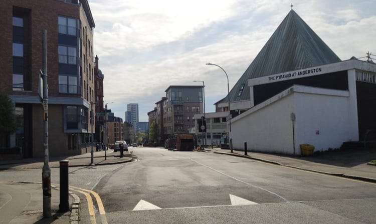
This is about main active travel routes being closed during October/November around the COP26 climate conference at the SEC. The ‘exclusion zone’ would cover a large area from Ferry Rd to Finnieston St and bridges in Anderston. The cycling diversions will be much longer and less safe than the parts of NCN7 and the West City Way that they replace. GoBike started a petition about keeping routes open (for Glasgow residents only). We also proposed changes to the council’s plans.
See our blog about the closures for more in-depth information and our social media for updates. GCC access rights consultation ends Friday 3 September.
1.3: Rosemount Development Trust – Royston Road Masterplan
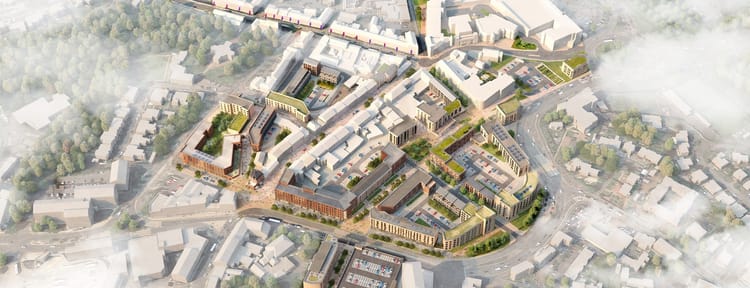
This debuted last time in Digest 93, 1.5. It’s about regenerating the western part of Royston Rd. It’s a part of the City Centre AQMA but not in the LEZ. That doesn’t seem to be mentioned while speeding, litter and other issues are. Equally, the project phases outlined in board 6 don’t include cycling at all. Surely it has to be part of the solution, especially with On Bikes’ Flourishing Molendinar project (Digest 92, Item 1.2) just up the same road? This Royston Rd project and theirs both need safe active travel connections to the city centre and Sighthill.
If you know the area at all, please put the case for cycling infrastructure. See the Royston regeneration survey and information boards (ends Friday 3 September).
1.4: Glasgow City Council – Inner East Strategic Development Framework
Another SDF (and another AQMA – Parkhead Cross) first covered in in Digest 90, Item 1.4. ‘Inner East’ is an arbitrary area made up by the council, who’ve decided Parkhead is the main place East Enders want to get to. While the Forge Shopping Centre is important for many, there’s an assumption here that all roads lead to Parkhead (including phase 3 of the East End Regeneration Route dual carriageway). A train station for Parkhead gets a few mentions but that’s what the East End Local Development Strategy said back in 2008. Active travel is mentioned a lot but road-building still seems to be central.

There are many more assumptions (“locals prefer to drive to the forge”) and errors in this SDF. The maps seem rushed, especially the Bridgeton map with two wrong train stations superimposed on it.
On a more positive note, there are a few mentions of permeability. One is about the paths through the Meatmarket site (under construction at Duke St/Bellgrove St) and there are other examples not in the document, like Riverside Dalmarnock.
The council talks up some recent developments by GCC and partners like Clyde Gateway, who have built a lot in the East End in the last decade or so (and do include cycle parking in their developments). However, people have to cycle through the car park of Red Tree, Shawfield as CG didn’t reconnect the path properly between NCN 756 and the Smartbridge (despite being asked). GCC also missed an opportunity to add protected cycle lanes in its Calton-Barras Action Plan (CBAP). So, there are still lessons to be learned.
See the Inner East consultation page for link to the SDF survey (ends 3 September).
1.5: Renfrewshire Council – Improving Barshaw Park Junction, Paisley
In Digest 93, 1.7 we mentioned the plans to improve safety for cycling at Barshaw Park junction. Option 3 had segregated cycle lanes on all roads, while options 1 and 2 only had them on the main road. There was some local hostility to the plans on Facebook – while not surprising on that platform, the plans will need support to progress.
See the Barshaw Park junction community survey to rate the options (ends 5 September).
1.6: Queens Cross Housing Association – Woodside Making Places: Planning Application
Woodside Making Places is a wide-ranging project for the area around St George’s Rd and Braid Square, near Garscube Rd. The previous consultation was in Digest 79, Item 1.4 (and an earlier stage in Digest 65, 3.1). This latest development wasn’t publicised much but was in a Glasgow Live article about Queens Cross Housing Association submitting a planning application.
It’s application 21/02266/FUL for “Renewal of public realm, gardens and greenspaces, including streets and lighting, with comprehensive green infrastructure improvements.” These include some playparks and a lot of tree planting. The most interesting part for GoBike is the ‘Quietway’ cycle route in the plan for North Woodside Road.

The red tarmac makes it look like a Dutch ‘bicycle street’ (where bikes have priority and cars are ‘guests’). Whether or not it will work that way remains to be seen. However, N Woodside Rd is a residential street, which is already filtered to the west at the junction of Maryhill Rd and Hopehill Rd (as featured in Digest 93, 3.3).
N Woodside Rd’s eastern end will link to segregated cycle lanes on St George’s Rd, which are part of the Connecting Woodside Project (and lead to the protected junction at Garscube Rd). So, it should be an important link for the wider area.
There was also due to be an improved path south to Phoenix Rd and the planned ‘Underline’ cycle route below the M8 between New City Road and Cambridge St. However, M8 emergency repairs are underway on the Woodside Viaduct so those Avenue works are being pushed back even further; potentially for a few years.
Deadline for any comments is 6 Sep. See the Woodside Making Places website for more background about the project.
1.7: Sustrans – Gartnavel Active Travel Feasibility Study

This project first came up in Digest 60, Item 3.3 and most recently in Digest 90, Item 3.2. Several GoBike members know the area and engaged with early ideas for the site. A site visit took place in July, when GoBike member Caroline met with the design consultants, ERZ Studio.
The initial proposals from that process are now out for consultation:
- Three shared/side-by-side walking/cycling routes across the site.
- Two new gates created in existing site wall.
- Adjusting crossings at main road junctions.
- Pedestrian precinct/plaza at main hospital buildings.
- Improving access towards Hyndland train station.
- Improving wayfinding signage.

The new northern gate would be next to the existing exit road (as above). However, the proposed eastern gate would open up access from a new location east of the Beatson, through the current stone wall, to Hughenden Lane (where you can see the chimney near the Beatson). This ‘Quietway’ would be an alternative route between Hughenden and Crow Rd, avoiding the very busy Great Western Rd. While it meanders a bit, it should also link to the more direct Shelley Rd (to the north, alongside Bingham’s Pond).

The scope of the project seems to have grown slightly from NHS-owned land to include crossings but not cycleways on the main roads themselves, like Gt Western Rd. Instead, the consultants asked about routes between NHS sites, like Gartnavel and the Queen Elizabeth University Hospital. One query was about a route via the soon-to-be-built Partick–Govan bridge to the QEUH; a mile longer than using the Clyde Tunnel (but might have less closures?).
For now, see the Gartnavel survey – ends 10 September.
1.8: East Renfrewshire Council – Ayr Road (A77): Spaces for People, Phase 2
Covered in Digest 91, Item 1.5, Ayr Rd through Newton Mearns is in a phase 2 consultation. It’s about replacing the phase 1 cones with light segregation, removing some segregation and adding parking bays. For examples of the segregation, maps and more details, see the Ayr Road Phase 2 Commonplace page. No obvious deadline on this one (but still seems to be open).
1.9: East Dunbartonshire Council – Active Travel Discussion
What can we say about the EDC Active Travel Discussion that hasn’t already been said? There are two more online events left. See the Active Travel Discussion page – ends 28 September.
1.10: Glasgow City Council – Secure City Cycle Parking Survey
Back in Digest 88, in the Infra Update, we mentioned how GCC’s tweet about neighbourhood secure cycle parking drew comments about it missing out the city centre.
Recently, the council launched a survey about “secure cycle parking in the city centre at travel hubs and places of employment.” They want to find out the following:
“a greater understanding of travel patterns, frequency of travel, and what type of provision would appeal to those who require to park their bicycle in the city.
The survey is anonymous and will take approximately 10 minutes to complete.”
Cadogan St multi-storey car park used to have a bike parking area but it wasn’t the most welcoming place. Perhaps Glasgow could aim for facilities like this office development in Bristol or Manchester’s Cycle Hubs.
Considering the spate of bike thefts across the city during the pandemic, this seems like a good chance to ask for more secure bike parking. See the GCC city centre cycle parking consultation page and cycle parking survey – ends 3 October.
Section 2: Forthcoming Consultations
None this time.
Section 3: Consultation Feedback
3.1: Glasgow City Council – TRNSMT Festival and Access to NCN75
In Digest 93, Item 3.4 we featured an email from GCC about the closure of NCN75 during the upcoming music festival. GoBike convenor Thomas tweeted about issues with the diversion route and replied to the council’s email. A further response from GCC sounds more constructive than before:
“To advise we are working to improve wherever possible the diversion route… which would hopefully make this route not only a suitable diversion for Major Events within Glasgow Green but also an optional route on a day to day basis.”
The council also wanted to organise a meeting between GoBike and council officers. They said: “we can walk the route highlighting where we will be making improvements”. Also, they would: “allow you an opportunity to speak directly with those planning/managing any works.” We wait to see the improvements but this new ramp was spotted on the route.
Lastly, GCC will “consider a short term working group to hopefully give an opportunity to facilitate improved joint working for the longer term solution to this particular challenge.”
Thomas will set up the meeting shortly and we hope to have further news.
3.2: North Lanarkshire Council – Bellshill Gateway & Cycle Facilities project

In Digest 92, Item 1.9 we featured initial plans for a proposed Velo Park and enhanced entrance to Strathclyde Country Park from Bellshill. A GoBike member was at a recent meeting between local groups and council staff. They’re from NLC’s new Greenspace Projects team, which will have responsibility for ‘Country Parks for the Future’ initiatives at Strathclyde Park (as well as Drumpellier Park in Coatbridge and Palacerigg Park, near Cumbernauld).
The officer clarified a few points, including that the planned mountain bike trails would only be in the north-east of the site. The paths around the South Calder Water would form a loop for walking and cycling as a local exercise route.
The team are looking at a few other issues like the underused hire bikes at the Watersports Centre (including some adapted bikes). Also, a potential cycle hub near Motherwell train station (perhaps in a building nearby).
A bid is due to go in to Sport Scotland by the end of August.
3.3: Glasgow City Council – London Rd Spaces for People lanes at Celtic Park

In Digest 90, Item 3.1, we covered the removal of the temporary ‘zebras’/’armadillos’ on London Rd outside Celtic Park and the Emirates. As well as contacting the council, some GoBike members put our message on London Rd itself.
GCC have taken a while to respond, perhaps because they had homework to do – according to their response…
“a survey of many similar sports facilities around the UK was undertaken and no examples of cycle segregation directly outside these facilities was found. Those that did have cycle facilities had a painted line only. GCC has improved on that by installing a ridged line to provide an audio and visual warning to drivers.
The Department explored alternative options including traffic delineator wands, such as those used on Great Western Road and a combination wand / armadillo design as currently used in Edinburgh City Centre. However, both of these also resulted in significant risk and possible increased risk in the case of the traffic delineator wand.“
The ‘combination design’ became a trip hazard on a high street in Cardiff. However, the above seems to rule out a ‘traffic delineator wand’ (temporary bollard) because it might be a risk.
Circumstantial evidence?
Several GoBike members were sceptical of the reasons given about ‘armadillos’ being a trip hazard. The council’s response says it depends on the circumstances:
“We do not consider that in normal circumstances armadillos represent a high risk trip hazard. However,… mass evacuation… (of) almost 60,000 individuals… would result in a tightly knit, panicked and distressed crowd. Under these circumstances, there would be little visibility of the armadillos and there is a significant concern of serious injury or fatality due to trips / falls and subsequent crush injury.”
There was a crush outside Celtic Park in 2018, where a few fans were injured. However, it was at the confined Janefield St side of the stadium, not the open London Rd side.

Apparently, the decision to remove was: “assessed in conjunction with advice from Police Scotland but no formal record has been kept”. There was no Equalities Impact Assessment “as this process is not appropriate for this type of alteration. None of the protected characteristics as outlined in the Equalities Act are negatively affect by the alterations.”
GCC talk about policy then make an interesting statement. “Designers have a duty under Construction Design and Management regulations to design out risk wherever possible.“
Lastly, they turn from the temporary Spaces for People project to mention the permanent East City Way route on London Rd. “We note your comment about the new East City Way and can confirm that the SFP project officers have discussed these issues with the East City Way officer with a view to designing out the risk as far as reasonably possible within the long term plans.” So, that seems to depends on the circumstances as well.
3.4: East Renfrewshire Council – Proposed Local Development Plan 2
We covered East Ren’s proposed Local Development Plan 2 in Digest 47, Item 1.4 in late 2019. It was submitted to the Scottish Government for its Reporters to consider in their 435-page report! It contains several mentions of GoBike, and our convenor Thomas (with his surname spelled correctly most of the time!).
One of these mentions – ‘(e) Schedule 6: Proposal D8.13: Netherlee to Giffnock’ – was about a potential feasibility study for a footbridge across the railway at Gordon Dr. The report shows there were two people in favour and 19 against so the proposal has been dropped (and will not be in any of their back yards). However, other measures GoBike supported will be included. The 22-page recommendation document details the text changes ahead of publication.
3.5: Glasgow City Council – Auldhouse Area Traffic Management Order
These measures for Auldhouse, in the Southside, appeared in Digest 92, Item 1.8. GoBike’s response made points about one-way streets and potential for contraflow cycling. The council sent a fairly predictable reply:
“…given the narrow carriageway widths and short lengths of carriageway within this self-contained residential area, contraflow cycle lanes were not deemed feasible. Unfortunately, I can therefore advise that cyclists will also be subject to the one way operations.”
GCC’s email goes on to say one-way streets will apparently “enhance road safety for cyclists”. Also: “parking restrictions at road junctions will remove potential obstructions by vehicles at lowered kerbs which will assist pedestrians, wheelchair users and push chairs in crossing the road.” There’s no mention of a joint decision with Police Scotland on enforcement.

