Glasgow City Council to no longer count bus lanes as cycle routes!
GoBike is heartened to learn this week that Glasgow City Council will no longer be counting bus corridors as part of the city’s cycling route network. Years of wishful thinking had allowed GCC to claim 310km of cycle routes in the city by counting any road designated as a bus corridor - even when some included roads are without bus lanes for long stretches. We hope that this newer, more realistic approach will allow officers and elected members to fully appreciate the work that needs to be done to fulfill the aspirations in the council’s Strategic Plan for Cycling.
GoBike have for years been asking GCC to stop using such an artificially inflated figure as 310kms, which is found repeatedly in the Strategic Action Plan for Cycling, and touted regularly in their press releases. This figure does nothing to help people who find it intimidating to cycle in the same space as multi-tonne buses and cars. Bus corridors typically follow high-traffic roads such as along A82 Great Western Road or A8 Edinburgh Rd, which are very desirable direct routes for cycling but are currently only a realistic option for a small number of people willing to brave these roads on bikes. The small number of high quality protected cycle lanes in Glasgow haven’t been built on these roads, despite the obvious utility to thousands of people, in part because according to the previous cycle route criteria they were already fine!
The realisation has been dawning within GCC over the last few years that people cycling really do need segregation from motor traffic on busy roads, and that realistic cycling journeys depend on a connected, comfortable network. We’re seeing more and more ambitious projects like Connecting Woodside, the Avenues strategy, and the proposed southern extension of the South City Way from Victoria Road to Battlefield and beyond. Hopefully the new recognition of the uselessness of bus lanes and bus corridors for cycling everyday journeys will translate into better prioritisation of roads for investment into cycling-specific infrastructure built to the highest recognised international standards, and an accelerated programme of filtering through motor traffic from residential neighbourhoods and shopping streets.
The council certainly haven’t got it right in the past, and continual scrutiny is needed to ensure that officers don’t become complacent - it is only through the campaigning efforts of GoBike and other organisations, that the key network link of Byres Road will have segregated cycling provision, and the ongoing disappointment of nearby University Avenue (still counted by the council as “traffic calmed with low traffic”!) shows how often developers are still allowed to get away with sticking on dangerous painted “cycle lanes” as an afterthought. Currently, on road painted lanes such as those in the door zone on Kilmarnock Road, and the newly painted particularly dangerous ones on Clarence Drive, are still counted as “cycle routes” (many of the blue lines on their updated map), and we would challenge the council now to take an even braver look at exactly what they should really be including as safe cycling infrastructure in their city
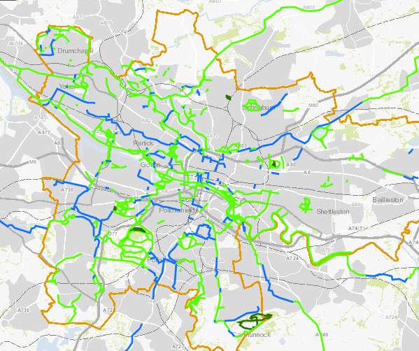
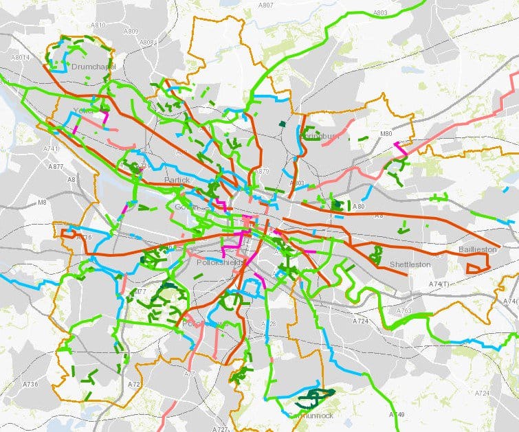
By looking at Glasgow’s online cycle map it’s possible to see how much the previous assessment of the cycling network relied on the presence of bus corridors.
With bus corridors (red lines):
Without bus corridors:

It’s very clear from the maps now how patchy the usable cycling network is, and where investment needs to be targeted to fill in the gaps. GoBike will continue to support Glasgow City Council where they plan infrastructure to make it easier, safer and more pleasant to cycle, and we’ll continue to challenge them where they don’t.
Thanks to member John Chivall for writing this blog for GoBike.

